
Urban Flooding Solutions: How Cities Protect $100 Billion in Assets
Urban flooding threatens cities with billions in asset losses. This blog explores modern, data-driven urban flooding solutions using GIS, remote sensing, and AI-powered planning. Learn how cities protect $100 billion in infrastructure, prioritize investments, reduce risk, and build resilient, climate-ready urban environments with smarter design decisions and long-term sustainable growth. · January 8, 2026

Urban flooding is no longer just a seasonal inconvenience. It is a global financial threat.
Cities across the world are losing billions every year due to floods, which cause drainage failures, infrastructural breakdowns, and damage to assets. With climate change, extreme rainfalls, and a rise in sea levels becoming ever more pertinent, all urban regions are expected to answer one important question.
How can we protect the people, the property, and the infrastructure amidst this climatic risk?
For urban planners, architects, and municipal leaders alike, urban flooding solutions are the core of their infrastructural investment strategy.
Urban flooding solutions in today’s day and age do not rely on just pumps, drains or emergency repairs. It is a data-driven discipline that uses simulation-powered systems to safeguard $100 billion in urban assets globally.
This article will shed light on the modern urban flooding solutions and how modern tools like Digital Blue Foam (DBF) are empowering decision-makers in building flood-resilient infrastructure.
The $100 Billion Challenge: Why Urban Flooding Demands a New Playbook
Urban flooding today is a result of numerous aspects. This includes:
- Higher and more unpredictable rainfall intensity
- Replacing green covers and permeable surfaces with concrete
- Aging or underequipped drainage systems
- Poor watershed management
- Habitat in low-lying or reclaimed land
These factors have a grave impact on the financial health of the cities as much as they contribute to environmental degradation.
Floods and stormwater lead to property damage, be it commercial, retail, or residential assets, depreciating their value.
It also leads to downtime of critical infrastructure, a rise in business interruption costs, and an increase in repair and insurance costs.
Municipal corporations across the world are looking at urban flooding solutions to:
- Protect asset value
- Safeguard investor trust
- Reduce liabilities
- Ensure long-term functionality of infrastructure.
With its pivotal nature, urban planners and municipal leaders across the world are looking at flood resilience solutions as not just an engineering intervention but as an asset-protection strategy.
GIS: The Foundation of Urban Flood Planning
Geographic Information Systems (GIS) is at the center of modern flood management.
For urban planners and municipal corporations, GIS is necessary to understand the behaviour of water across the city.
Here’s how GIS helps in smarter flood resilience:
Flood Zone Identification and Mapping
With the help of elevation models, soil data and drainage profiles, GIS can pinpoint:
- Natural depressions
- Weak drainage areas
- Water accumulation areas
- Low-lying sections that are at a higher risk
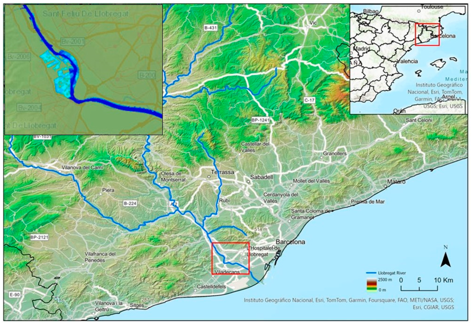
Barcelona is a prime example today that uses high-resolution GIS flood maps to enforce zoning overlays and define redevelopment policies.
Asset-Level Vulnerability Assessment
GIS can help map out commercial assets, utilities, public buildings, transit corridors, and other critical infrastructures. This can help planners quantify financial risk under different flooding scenarios.
Investment Prioritization
When presented with a risk and asset value with respect to different flood scenarios, municipal corporations can answer multiple questions better. They can decide where to modify zoning, where to build retention, or where green infrastructure will have maximum ROI.
Real-Time Monitoring Dashboards
GIS dashboards can allow cities to visualize the intensity of rainfall, track drainage performance, monitor water levels and trigger emergency action. This enables cities to look at flood response as a data-alerted preventive measure rather than a reactive one.
Remote Sensing: The New Lens on Urban Flood Risk
With GIS offering a spatial foundation, remote sensing provides dynamic insight into resilience planning. Here’s what remote sensing can offer:
Satellite-Based Floodplain Delineation
When planners have access to high-resolution imagery, it helps them check:
- Annual patterns
- Historical occurrence of floods
- How natural flow corridors were impacted by development
Dhaka is an example of a city that uses multi-temporal satellite maps to update its urban flood zoning regularly.
Multi-Temporal Flood Severity Analysis
Remote sensing helps planners and designers study the frequency, depth, and duration of floods and land cover changes that affect runoff. This is very important for regions that are undergoing rapid urban expansion.
Vegetation & Soil Moisture Detection
Any change in vegetation density, soil compaction and impervious surface growth has a direct impact on the runoff and flood velocity.
Radar-Based Storm Tracking
Radar systems are very critical as they can forecast rainfall and its intensity hours before it happens. This can help authorities take necessary early action in vulnerable districts.
GIS + Remote Sensing: A Powerful Pair for Asset Protection
Urban flooding solutions of today use a combination of both technologies to create a unified decision engine. The benefits are multi-fold and include:
Flood Vulnerability Index Linked to Financial Exposure
Cities across the world can now assign risk scores to different regions based on flood depth, frequency, proximity to damage, sensitivity of infrastructure, and other factors. This can help instill trust among stakeholders with respect to investments and asset valuation.
Rainfall-Runoff Simulation for Loss Prevention
Remote sensing powers hydrological modelling, which helps planners understand where water accumulates, how fast it moves and which assets are in the flow path. Simulating this helps cities quantify damages avoided with the help of proactive interventions.
Zoning and Code Reform
With tech-driven solutions, planners can have data-driven insights that support overlay zones, setback rules, and define restrictions in high-risk corridors.
Better Early Warning Systems
Integrated platforms use data to allow emergency agencies to issue alerts, mobilize response and prepare evacuation routes.
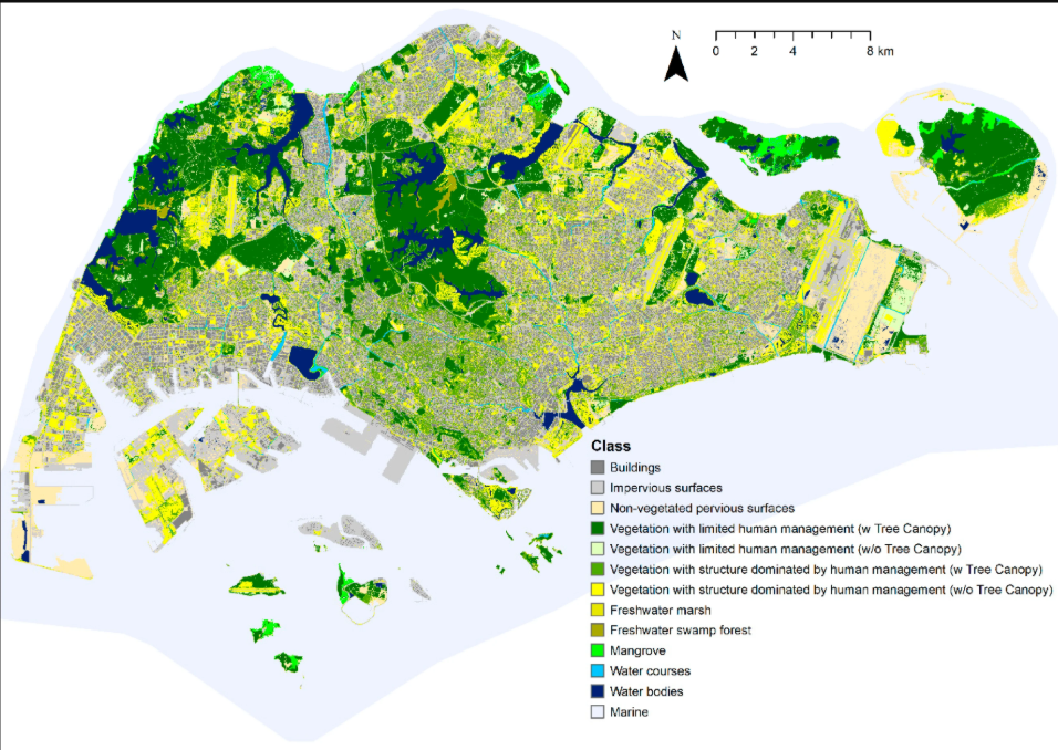
A combination of these systems can be seen in use at some of the biggest cities in the world. Singapore uses an integrated drainage system with a real-time GIS. This can be seen in the way they use smart live dashboards, drainage tunnels, and detention ponds.
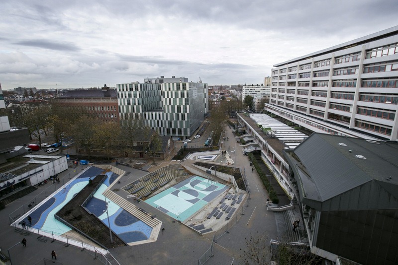
Rotterdam uses water squares for multi-use flood storage. Here, different public plazas double as flood retention basins protecting the nearby surroundings.
Barcelona has a GIS-based micro-drainage strategy. The city implements localized resilience planning with high-resolution modelling.
How DBF Helps Cities Protect Assets from Flooding
Digital Blue Foam is at the forefront of helping planners and architects in building urban flooding solutions. The solution customised by DBF can combine AI-powered generative design, geospatial intelligence, and flood-resilient management in one interface. This is done by:
Visualize Flood & Elevation Risk During Early Design
DBF helps in layering all the important data into the plans through its workflows. Elevation, drainage, slopes, historical flood zones, and runoff pathways, among other things, are considered right from the beginning. With the help of this data, one can identify the zones that are prone to flooding and work on a mitigation plan before the infrastructural development design begins.
Integrate Flood Data with Asset Value for Smarter Investment
DBF helps planners to integrate real estate value, infrastructure cost and flood risk layers together. This enables municipal authorities and developers to make informed capital decisions.
AI-Driven Generative Layouts for Resilience
DBF, with its AI-generative capabilities, can help planners and architects simulate multiple scenarios. Factors such as permeable surfaces, retention zones, building placement, water routing patterns, and elevation strategies can be considered during the design phase. This helps in reducing flood exposure while maintaining development yield.
Support for Resilience Reporting
DBF provides planners with all the pertinent information with respect to the site’s resilience. This includes climate indicators, impact summaries, compliance support, and data-rich presentations for stakeholders and insurers. With data-backed insights, DBF helps make resilience justification measurable and transparent.
Conclusion
Urban flooding is one of the biggest challenges of our time. Its impact is financial, infrastructural and psychological and needs to be addressed keeping in mind sustainable, climate-friendly innovations.
With cities growing rapidly, climate risks are only bound to increase. And this pushes planners and municipal leaders to adopt predictive, data-backed urban flooding solutions.
Tools like Digital Blue Foam are at the forefront of this shift. By helping cities test different scenarios and designs, ensuring they always take a strategic approach towards design and building rather than a reactive one.
If you are a municipal planner looking for customized solutions, the product design team at DBF will aid in bringing them to life.
FAQs
What is the economic impact of urban flooding?
Urban flooding results in losses that can go into the billions. Damaged buildings, infrastructure, utilities and land value all have a severe impact on municipal budgets and investor confidence.
How do GIS and remote sensing help cities protect assets?
GIS and remote sensing help provide high-resolution flood mapping, different elevation models, historical data, and real-time monitoring. This allows authorities to identify risk, prioritize investment, and design better systems.
What are the most effective urban flooding solutions?
The most effective urban flooding solutions are also the most common ones. These are adaptive landscapes, updated drainage networks and systems, flood-responsive zoning, detention basins, among others. In today’s day and age, AI-powered planning tools are also effective in simulating runoff and risk.
How does DBF help model risk and improve resilience planning?
DBF helps planners and developers with all the data points they would need before designing the project. From elevation, runoff, flood-risk layers, to the multiple scenarios that can be mapped out thanks to generative design and ROI simulation. All of these features can aid in identifying the city’s exposure, helping it mitigate risks by designing the right solutions.
