
What are the Benefits of BIM in Urban Planning?
BIM revolutionizes urban planning by integrating data into 3D models for better visualization, collaboration, forecasting, and sustainability. It helps planners predict outcomes, streamline approvals, and design smarter, greener cities. Tools like Digital Blue Foam make BIM adoption easier, bridging early-stage urban design with BIM-ready outputs for faster, more accurate project execution. · May 9, 2025

As cities grow faster than ever, planners are struggling to keep pace with real-world demands. Even though data is more abundant than ever, it is often found in silos, chaotic PDFs and intangible reports.
Building Information Modeling (BIM) is revolutionizing how data is used for the analysis and execution of urban development products. It is emerging as a key tool for urban designers to evaluate, eliminate, and visualize changes before they happen.
This blog explores how and why BIM matters to urban planners, the benefits of BIM in urban planning, and its relevance in the context of smart cities and data-driven design.
What is BIM?
Building Information Model (BIM) is usually misunderstood as an exclusive tool for managing architectural and construction projects. In reality, it is much more than that. It is a digital process that uses 3D models as a foundation. It enables architects, engineers, real estate developers, contractors, and other construction professionals to plan, design, and execute any project within one 3D model.
BIM helps stakeholders see exactly what a site is going to look like and have all relevant information available in one centralized, actionable repository. This allows teams to run simulations, detect clashes, and forecast outcomes before construction begins.
Why does BIM matter for urban planners?
The traditional urban planning system includes challenges like inefficiency, data collection, coordination, environmental impact, and more. BIM has emerged as a solution to these issues, offering a multidimensional understanding and responsive design frameworks by -
- Urban data integration across systems - Consolidating zoning laws, infrastructure networks, environmental datasets, and more within a single visual model.
- Process transparency and collaboration - Real-time coordination between multiple stakeholders, like architects, engineers, city officials, and everyone involved.
- Predictive modeling and simulation - Allowing urban planners to test multiple options before implementing.
- Sustainability benchmarking - Evaluating energy consumption, inventory management, and carbon performance in the early planning stage.
For professionals seeking to adopt BIM, tools like Digital Blue Foam provide an accessible entry point to explore BIM in urban planning.
Core Benefits of BIM in Urban Planning
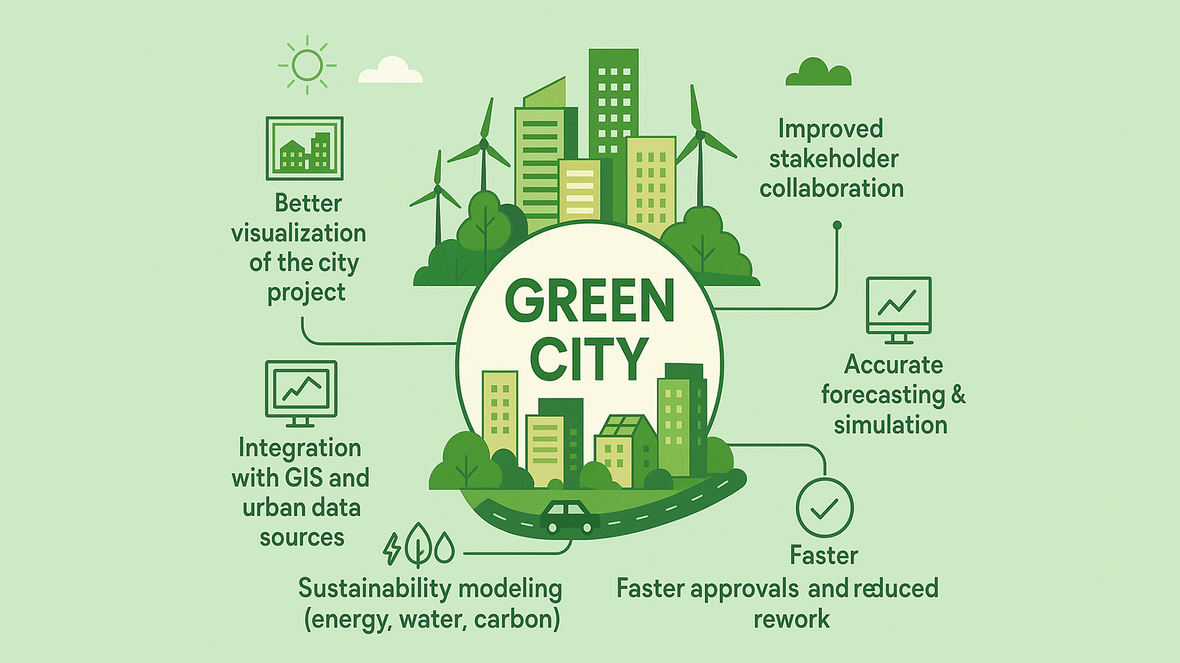
- Better visualization of the city project
One of the most immediate benefits of BIM is the ability to create accurate urban environments in 3D models. Unlike 2D plans, BIM-generated models offer spatial understanding, like building massing, terrain, infrastructure, and neighbourhood. Planners can visualize how new development will impact the existing city in terms of skyline, shadows, and views.
Data-rich 3D representations don’t just illustrate the city but stipulate how the city will evolve over time. Planners can explore variations in density, test shadow impacts, assess public realm connectivity, and communicate proposals effectively to non-technical stakeholders.
- Improved stakeholder collaboration
When it comes to collaboration, all stakeholders, including architects, engineers, facility managers, and city developers, should be able to track the progress in real time. Since all the stakeholders get to work through one centralized system, there is less chance of errors. And even if misunderstandings and clashes happen, it can be detected long before the time to ensure a smooth workflow.
BIM provides a shared digital environment that supports collaborative planning tools. This approach is important in large-scale masterplanning, where delays and design errors can lead to costly consequences.
- Integration with GIS and urban data sources
BIM’s power is amplified when integrated with GIS. This integration allows urban planners to overlay building-level intelligence with contextual data such as flood zones, transit infrastructure, demographic patterns, and land use regulations. It leads to a better framework where strategic vision meets spatial feasibility.
For instance, a planner can use GIS layers to identify flood-prone zones, then use BIM to identify how different architectural forms might perform under those conditions. It can also connect micro and macro scales by offering data-driven planning insights.
- Accurate forecasting & simulation
Another key advantage of BIM in urban planning is forecasting. It provides tools to derive data for complex environmental and infrastructural scenarios. BIM enables predictive simulations that extend into multiple domains like transportation flows, microclimate behavior, water management, and energy consumption.
For instance, urban planners can predict how new developments will impact the local wind flow and carbon emissions in a particular area, based on material selection and building orientation. This way, BIM helps urban planners to transform planning from a reactive process into a predictive discipline, leading to decisions for a measurable long-term impact.
- Sustainability modeling (energy, water, carbon)
With growing climate concerns, sustainable design is no longer optional. By using BIM for sustainable cities, urban planners can add environmental considerations from the very early stage of planning. They can evaluate how the development of cities in terms of energy consumption, water consumption, carbon emissions, and more.
Planners can weigh long-term impact, optimize materials, and design for better climate response. By using these features, planners can adjust developments to achieve green building certifications and meet municipality sustainability targets.
- Faster approvals and reduced rework
Getting approvals in urban planning isn’t always smooth. Paperwork piles up, submissions don’t align, and every revision adds weeks to the timeline. BIM fixes this by streamlining all relevant project data into a single, coordinated file. This allows planning authorities to vet proposals more efficiently and reduce the time spent navigating inconsistent submissions or conflicting reports. It is especially powerful in BIM for infrastructure, where alignment with public guidelines is critical.
By using BIM’s automated rule-checking and clash detection features, authorities can identify compliance issues early and minimize the need for multiple revisions. For instance, if a proposal doesn’t meet height limits or violates a setback, BIM highlights it before it becomes a bigger issue. This not only accelerates the review process but also reduces rework costs and delays during implementation.
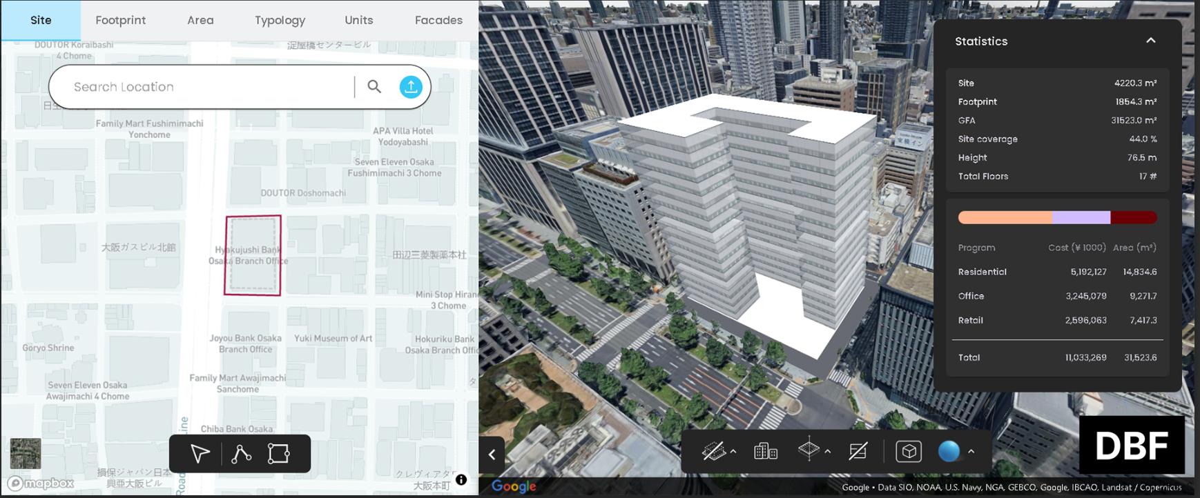
.png)
These examples highlight how BIM enables cities to move from reactive planning to anticipatory governance.
How Digital Blue Foam Enables BIM-Driven Urban Design
While the benefits of BIM in urban planning are well-established, access to its full potential often remains limited by technical barriers, disconnected tools, or time-consuming workflows. Digital Blue Foam (DBF) addresses these challenges by offering an integrated platform that bridges the gap between early-stage urban design and BIM-ready outputs. It empowers planners, architects, and policymakers to work faster, more collaboratively, and with greater data accuracy.
Our platform is designed to help urban planners:
- Seamlessly integrate zoning, climate, mobility, and demographic data
- Run urban-scale design simulations and scenario testing
- Transition smoothly from early-stage sketches to BIM-exportable models
In short, DBF empowers urban professionals to move from idea to implementation with confidence, clarity, and technical precision, all while supporting sustainable, future-ready outcomes.
In Conclusion
The usage of BIM in urban planning is transforming cities, moving urban design from fragmented, reactive methods to integrated, data-driven strategies. It enables planners to visualize complex environments, collaborate effectively, simulate real-world outcomes, and embed sustainability from the start.
Yet, the true potential of BIM is unlocked only when paired with tools that simplify its adoption. Digital Blue Foam offers exactly that - a platform that streamlines early-stage design, integrates real-time data, and delivers BIM-ready outputs.
As urban challenges grow, adopting BIM-powered workflows becomes essential. With DBF, planners can move from vision to implementation with speed, precision, and clarity.
To see how Digital Blue Foam can support your next urban project, request a demo or explore our planning tools today.
FAQs
- How is BIM used in urban planning?
In urban planning, BIM is used to build 3D models with data like zoning, infrastructure, and environmental conditions. This makes it easier to test ideas, predict outcomes, and align all stakeholders.
- What are the benefits of BIM in the design phase?
When used from the start, BIM helps the team detect design issues before they become real problems. It speeds up revisions, makes collaboration smoother, and lets you test for things like sustainability and code compliance while the design is still taking shape.
- What are the benefits of using BIM?
At its core, BIM helps reduce guesswork. You get clearer visuals, better coordination between disciplines, and fewer coordination errors. Since everything’s built around real data, decisions tend to be more thoughtful, especially when planning for long-term urban resilience.
- What is the role of BIM in smart cities?
BIM supports smart cities by enabling digital twins, real-time monitoring, and data-informed urban management. It connects physical assets with digital models to optimize performance, sustainability, and urban resilience.
- What is the use of GIS in urban planning?
GIS is used to map, analyze, and manage spatial data in urban planning. It helps assess land use, infrastructure, population patterns, and environmental risks. It provides essential context for informed planning decisions.
