
How Urban Planners Use Accessibility Analytics for Pedestrian Flow Management
Pedestrian flow management is one of those disciplines where the cost of getting it wrong is only fully visible after a development is occupied. Retail units that nobody walks past. Public plazas that feel exposed and are avoided. Transit connections that should draw people, but instead create dead zones. For urban planners and development teams responsible for large, complex projects, this gap between design intent and actual movement behaviour represents a significant and largely avoidable failure. · June 2, 2026


Accessibility analytics and AI-driven pedestrian flow management tools are changing the terms of this problem. By making movement behaviour predictable at the design stage and by connecting those predictions to specific spatial decisions that can be optimised, these tools give planning teams the evidence to design for how people actually move, not how designers assume they will.
The Problem: Why Traditional Pedestrian Flow Tools Fall Short
Most pedestrian movement analysis in large development projects is conducted using one of two approaches: post-occupancy counting surveys or agent-based simulation models. Both have serious limitations at the scale and speed that enterprise development planning requires.
Post-occupancy surveys produce accurate data about how people move through a completed development. They are useless for influencing the design decisions that determine those movement patterns, because by the time the survey is conducted, the development is built and the routes, widths, connections, and barriers are fixed. The analysis diagnoses a problem that only demolition can cure.
Agent-based pedestrian simulation tools like Legion, MassMotion, and VISSIM are powerful modelling instruments for specific, well-defined scenarios — stadium evacuation planning, transit interchange capacity assessment, and airport security queue management. They require extensive configuration, detailed architectural drawings as inputs, and specialist operators to run. At the concept design stage, when the spatial layout is still schematic and the brief is still evolving, these tools are structurally inaccessible. The setup overhead exceeds the value of the analysis for anything other than a defined compliance or safety assessment.
The result is that most large development designs are evaluated for pedestrian performance qualitatively — by experienced designers applying intuition about how people move — rather than quantitatively. This works for simple layouts. It consistently underperforms for complex, multi-level, multi-use environments where movement behaviour is determined by the interaction of multiple spatial factors simultaneously.
What Accessibility Analytics Actually Means in Practice
Accessibility analytics, in the urban planning context, is the systematic measurement and modelling of how easily and intuitively a development's spatial configuration allows people to reach destinations from any given point of entry. It encompasses several related but distinct analytical dimensions.
- Pedestrian connectivity analysis measures how well the internal route network of a development connects its key pedestrian generators and attractors. A development with poor connectivity is not necessarily one with too few routes — it may have routes that are geometrically indirect, poorly legible, or spatially unattractive.
- Catchment and isochrone analysis measures how many destinations can be reached from a given point within defined walking time thresholds — 2 minutes, 5 minutes, 10 minutes. This is particularly relevant for transit-oriented developments, where the commercial case for a transit investment is partly determined by the walking catchment it serves.

- Space syntax analysis examines the topological properties of a spatial network — the degree to which each route is visually and geometrically connected to the rest of the network — to predict which routes will carry the highest natural pedestrian movement. Space syntax has over four decades of empirical validation across retail, campus, and urban environments, consistently predicting observed movement patterns with 60–80% accuracy from spatial configuration alone, before any pedestrian behaviour data is collected.

How AI Is Changing Pedestrian Flow Management Workflows
The traditional workflow for pedestrian flow analysis requires a completed spatial layout — detailed floor plans or architectural drawings — before analysis can begin. This creates the same upstream-downstream problem seen in energy and daylight analysis. By the time the tool can be applied, the spatial decisions that most influence pedestrian flow have already been made.
AI-integrated accessibility analytics platforms change this by working from schematic layouts and urban context data rather than requiring detailed architectural drawings. A planning team can input a proposed development footprint, programmatic distribution (where retail, residential, office, transit, and public space are located), and connections to the surrounding urban network, and receive a predictive pedestrian flow analysis within minutes rather than days.
The AI does not replace space syntax or agent-based modelling for detailed compliance or safety assessments. It provides the upstream decision support that those tools cannot practically deliver at the concept stage. A planning team that uses AI-driven pedestrian flow management analysis to optimise the layout at the concept stage is using the specialist tools at Stage 3 to confirm performance rather than to discover that the spatial structure needs to be redesigned.
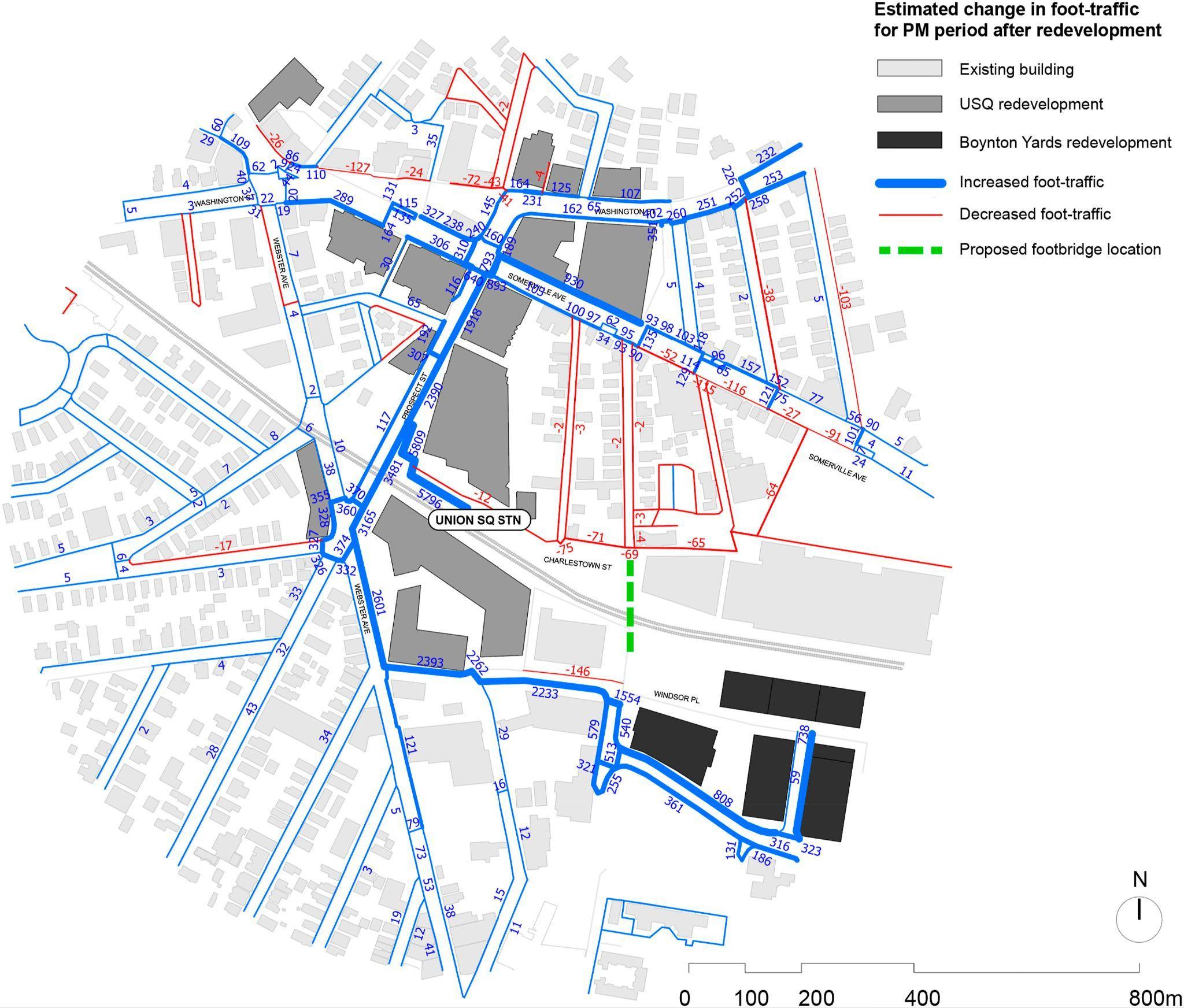
For large masterplan projects where the spatial layout involves hundreds of discrete route segments, public spaces, and building frontages, AI analysis reveals the system-level movement implications of local layout decisions. Moving a transit entrance 30 metres along a street frontage changes the space syntax integration value of the routes connected to it, and therefore changes the predicted natural movement along every route in the affected network. AI tools make these second-order effects visible at the design stage rather than observable only after occupancy.
Key Features That Matter Most in Pedestrian Flow Management Tools
Feature 1: Multi-Scale Analysis — From Plot to Precinct
Large development projects generate pedestrian movement at multiple scales simultaneously. At the plot scale, internal layout decisions — lobby placement, atrium configuration, and retail frontage arrangement — determine how people move within a building. At the precinct scale, the relationship between buildings, public spaces, and street connections determines how people move across the development. At the city scale, the development's connection to the surrounding urban network determines how much pedestrian movement the development attracts from beyond its immediate boundaries.
Effective pedestrian flow management tools need to operate across all three scales simultaneously, because optimising at one scale without understanding the others produces layouts that work locally but fail systemically. A perfectly designed ground-floor retail arcade becomes underperforming if the precinct-scale route structure does not bring sufficient pedestrian movement past its entrance. Multi-scale analysis capability is the feature that prevents this class of error.
Feature 2: Real-Time Layout Sensitivity Testing
For planning teams iterating on spatial layout at the concept stage, the most valuable analytical capability is not accuracy — it is responsiveness. The ability to test the movement implications of a layout change within seconds rather than submitting a new model for simulation allows design teams to explore the spatial configuration space efficiently, quickly identifying which layout decisions have the greatest impact on pedestrian flow performance and which are relatively insensitive.
This responsiveness is what distinguishes AI-integrated accessibility analytics from traditional simulation tools. Traditional tools produce a highly accurate result for a single, defined layout. AI-integrated tools produce directionally accurate results for any layout variant in real time, enabling the kind of rapid comparative analysis that concept design iteration requires. The two complement rather than replace each other — AI-driven real-time analysis at the concept stage, detailed simulation at later design stages for compliance verification.
How Digital Blue Foam Delivers on Pedestrian Flow Management
Digital Blue Foam's Spatial Analytics suite provides the multi-scale, real-time accessibility analysis capability that pedestrian flow management at enterprise development scale requires. The suite validates projects across multiple metrics using multi-source spatial data and proprietary KPIs, enabling data-driven decision-making from city-level network analysis down to individual plot and ground-floor layout assessment.
For pedestrian flow management specifically, DBF's platform integrates urban connectivity data, transit network coverage, ground-floor land-use distribution, and spatial layout geometry into a unified analytical environment. Planning teams can evaluate the pedestrian catchment implications of different site configurations, the connectivity performance of alternative internal route structures, and the transit ridership impact of entrance placement decisions — all within the same platform and at the design stage, where those decisions can still be changed.
Clients, including Emaar and Dubai Municipality, have used DBF's Spatial Analytics tools to validate pedestrian connectivity strategies for large mixed-use master plans, providing planning authorities with quantified evidence of pedestrian accessibility performance and using the analytical outputs to inform ground-floor activation strategies that maximise natural movement past retail and public space frontages.
Explore Digital Blue Foam's platform and Spatial Analytics capabilities for detailed information on pedestrian flow management tools and workflow integration.
Who Should Be Using This Approach
The planning and development professionals who gain the most from AI-integrated pedestrian flow management analytics share a common characteristic: they are responsible for spatial decisions whose movement consequences extend beyond the immediate site boundary.
Masterplanners and urban designers working on mixed-use precincts, transit-oriented developments, and large campus environments are the primary beneficiaries. The pedestrian movement performance of these project types is determined by system-level spatial decisions — the location and geometry of key pedestrian generators, the topology of the internal route network, and the quality of connections to the surrounding urban fabric — set at the masterplan stage and very expensive to change afterwards.
Transport planners and transit authority planners designing or improving transit interchange facilities are a second key user group. Interchange design is fundamentally a pedestrian flow management problem. The spatial configuration of a station, bus terminal, or interchange needs to route high volumes of pedestrians efficiently between modes without creating conflict points, bottlenecks, or dead zones.
Retail and commercial development managers are a third group with direct commercial exposure to pedestrian flow performance. The relationship between natural pedestrian movement — movement driven by route structure and connectivity rather than deliberate destination-seeking — and retail footfall is well-established in the retail planning literature. Developments where the spatial structure naturally routes high movement volumes past retail frontages consistently outperform those where retail is located in low-connectivity positions, regardless of the quality of the retail offer.
Getting Started: From Feasibility to Implementation
Integrating accessibility analytics into a development planning workflow does not require a wholesale process transformation. The most effective implementations begin with a defined question: which spatial decisions in this project have the greatest impact on pedestrian flow performance, and at what design stage are those decisions being made?
For most large development projects, the answer points to the masterplan stage — where the route network topology, key pedestrian generator locations, and connections to the urban context are established. Starting accessibility analytics at this stage, even with schematic geometry, produces directional guidance that informs the decisions with the highest leverage on eventual pedestrian performance.
The implementation path then follows the design stage: schematic AI-driven analysis at concept stage for layout optimisation, more detailed parametric analysis at Stage 2 to validate the shortlisted configuration, and specialist simulation tools at Stage 3 for compliance verification and safety case development where required. Each stage uses the tool appropriate to the design resolution available at that point.
The organisational change that makes this workflow function is the inclusion of pedestrian performance criteria in the design brief — specifying minimum connectivity scores, catchment coverage requirements, or space syntax integration thresholds as design constraints alongside GFA targets and cost budgets. When pedestrian performance is a stated design objective rather than an implicit aspiration, the analytical tools that measure it are used rather than deferred.
Conclusion
Pedestrian flow management is a design problem before it is an engineering problem. The movement behaviour that determines whether a development's public spaces activate, its retail succeeds, and its transit connections are used is largely determined by spatial decisions made at the masterplan and concept design stage. Accessibility analytics tools that make those decisions evidence-based, rather than relying on designer intuition, are closing the gap between design intent and occupied performance.
For urban planners and development teams responsible for large mixed-use, transit-oriented, and campus developments, the operational case for integrating AI-driven pedestrian flow management analytics into the concept design process is straightforward. The decisions that most influence pedestrian performance are made early, they are cheap to change when informed by evidence, and they are expensive to correct after occupancy.
To explore how Digital Blue Foam's Spatial Analytics suite supports pedestrian flow management and accessibility planning for large development projects, book a demo or explore the platform.
FAQs
What is pedestrian flow management in urban planning?
Pedestrian flow management in urban planning is the practice of designing and optimising the spatial configuration of developments, streets, and public spaces to support efficient, intuitive, and safe pedestrian movement. It encompasses route network design, entrance and generator placement, public space configuration, and connections to the surrounding urban pedestrian network. In large complex developments, pedestrian flow management determines whether the development's public spaces activate, its transit connections are effectively used, and its retail and commercial frontages attract sufficient natural movement for commercial viability.
What is space syntax, and how does it relate to pedestrian flow?
Space syntax is an analytical methodology developed at University College London that examines the topological and geometric properties of spatial networks to predict natural pedestrian movement. It measures the degree to which each route in a network is visually and geometrically connected to all other routes — a property called integration — and uses this to predict which routes will attract the highest volumes of natural, undirected pedestrian movement. Space syntax has been empirically validated across retail, campus, and urban environments, consistently predicting observed movement patterns with 60–80% accuracy from spatial configuration alone.
How can accessibility analytics improve retail performance in mixed-use developments?
Accessibility analytics predicts which retail frontages will receive the highest natural pedestrian movement based on their position in the development's spatial network. Retail units located on high-integration routes — those with strong connectivity to the development's main pedestrian generators and the surrounding urban network — consistently outperform units in low-connectivity positions regardless of the quality of the retail offer. By using accessibility analytics at the design stage to map predicted natural movement patterns, planning teams can locate primary retail frontages where movement volumes are highest and configure secondary uses in the lower-movement spaces.
What data is needed to run pedestrian flow management analysis?
At the concept design stage, AI-driven accessibility analytics tools require schematic layout geometry (building footprints, public space configuration, route network), programmatic distribution (location of key pedestrian generators, including transit entrances, building lobbies, and retail clusters), and connections to the surrounding urban pedestrian network. At later design stages, more detailed inputs — including floor plan geometry, pedestrian barrier locations, and level change configurations — are required for space syntax or agent-based simulation analysis. AI platforms significantly reduce the input data requirements compared to traditional simulation tools, making analysis practical at earlier design stages.
