
Enterprise Geospatial AI Solutions: Technology Stack Comparison for Large-Scale Urban Projects
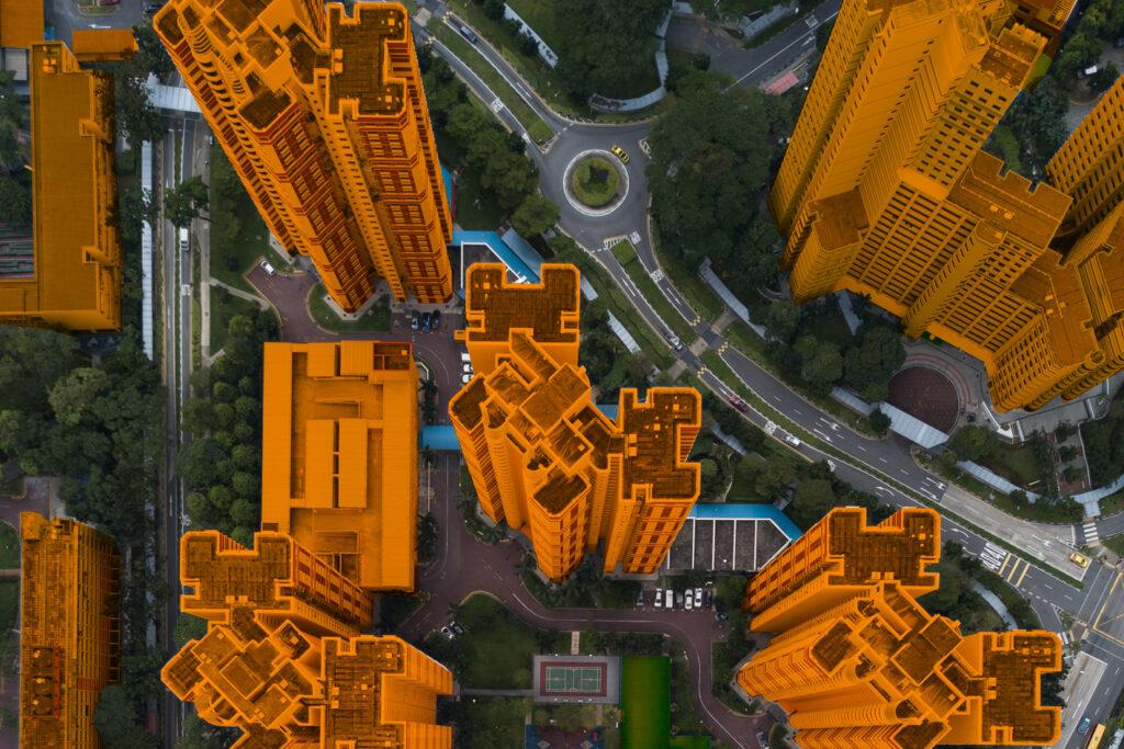
Cities have entered a genuinely data-rich age. Masterplanned districts, infrastructure corridors, logistics hubs, and climate-adaptive programs now generate constant streams of location-based information. Satellite imagery sits next to drone surveys, LiDAR scans, IoT sensor feeds, traffic telemetry, cadastral records, and BIM models. Together they form a living geospatial layer that maps the city's changing shape. · June 2, 2026


Cities have entered a genuinely data-rich age. Masterplanned districts, infrastructure corridors, logistics hubs, and climate-adaptive programs now generate constant streams of location-based information. Satellite imagery sits next to drone surveys, LiDAR scans, IoT sensor feeds, traffic telemetry, cadastral records, and BIM models. Together they form a living geospatial layer that maps the city's changing shape. The problem isn't finding data anymore; it's turning that into timely, usable intelligence. That's the promise of geospatial AI.
By blending geospatial analytics with machine learning, computer vision, and cloud-scale processing, it turns raw spatial inputs into predictive, decision-ready insights. Teams can automatically spot land-use shifts, model where infrastructure will appreciate, assess environmental exposure, simulate movement patterns, and benchmark asset performance across regions. In short, pixels and points stop being noise and become planning-grade signals.
For large urban projects, this is more than incremental; it's structural. Traditional GIS workflows relied on manual mapping and static snapshots. Geospatial AI adds automation, temporal awareness, and scenario modeling to the planner's toolkit. Planners aren't only looking backward; they can anticipate problems, detect development risks, track construction progress, measure impervious-surface growth, and evaluate climate exposure in near real time.
Procurement and strategy are changing, too. Infrastructure agencies, smart-city teams, utilities, and developers aren't just buying mapping tools anymore. They're evaluating integrated stacks — ML pipelines, spatial analytics, and enterprise deployment stitched together. Geospatial intelligence is moving from a specialist add-on to a core discipline in urban delivery.
The payoff is concrete: faster approvals, tighter risk control, clearer ESG reporting, and more resilient masterplans. As cities expand and climate pressures grow, embedding geospatial intelligence into planning workflows will shape the next generation of large-scale urban projects.

Geospatial AI Market Landscape
Market Size and Growth
Over the past five years, geospatial AI has slipped out of niche research labs and into mainstream enterprise buying cycles. Higher-resolution satellites and aerial imagery, denser sensor networks, cheaper processing, and more mature ML workflows have unlocked practical commercial use cases across urban planning, infrastructure delivery, utilities, mobility, and environmental monitoring.
Analysts consistently point to strong compound annual growth for geospatial analytics, driven by public-sector modernization, smart-city investment, and private capital aimed at the built environment. For enterprise-scale urban programs — masterplans, transit corridors, and large property portfolios — geospatial AI is quickly becoming a required component of the tech stack.
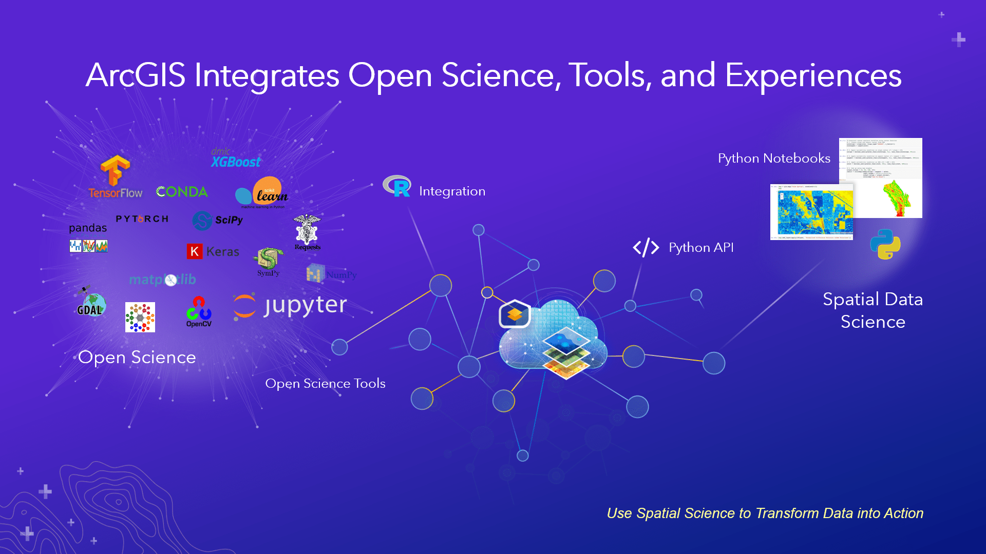
Key Technology Categories
If you're evaluating vendors or building in-house capability, these core components form a practical geospatial AI stack:
Data Ingestion & Management
- Ingesting satellite, aerial, and drone imagery (multi-spectral, high-res RGB, thermal)
- Bringing in vector and tabular sources (parcels, cadastral layers, land-use tables, sensor feeds)
- Point clouds and LiDAR processing pipelines
- Time-series ingestion for change detection and ongoing monitoring
Geospatial Data Processing & Storage
- Scalable raster and vector stores (cloud object storage, tiled map services)
- Spatial databases (PostGIS or cloud equivalents) and efficient indexing (quadtrees, H3)
- Preprocessing workflows: orthorectification, mosaicking, denoising, georeferencing
Machine Learning & Analytics
- Computer vision for segmentation, object detection, and instance tracking (buildings, roads, impervious surfaces)
- Time-series analytics for urban dynamics (construction progress, vegetation health, traffic flows)
- Transfer learning and domain adaptation so models generalize across new geographies
Model Ops & Deployment
- Containerized serving, autoscaling inference, and choices between batch versus streaming processing
- Experiment tracking, explainability, and retraining pipelines to manage model drift
Visualization & Decision Interfaces
- Web GIS, dashboards, layered map viewers, and scenario simulators that translate pixel-level outputs into planning KPIs
Integration & APIs
- Connectors for CAD/BIM systems, asset management, ERP, and planning tools, so spatial insight feeds existing workflows

Enterprise vs. Consumer Applications
The gap between consumer mapping apps and enterprise geospatial AI platforms is more than a feature list; it's about governance, scale, and trust. Consumer or SMB tools (simple map viewers and imagery apps) are great for quick visualization, exploration, and light annotation. They work well for individuals and small teams, but typically lack the operational controls required for mission-critical urban programs.
Enterprise platforms, by contrast, must deliver:
- Scalability: The ability to process continent-scale imagery, terabytes of LiDAR, and years of time-series data in both batch and streaming modes.
- Security & Compliance: Enterprise identity, audit trails, role-based access, and data residency — essentials for government and regulated infrastructure clients.
- Repeatability & MLOps: Productionized deployments, retraining, drift detection, and inference SLAs.
- Interoperability: Native connectors to BIM, GIS, and asset systems to close the loop from insight to action.
- Customization & Domain Expertise: Prebuilt models augmented with local retraining, bespoke classes, and domain ontologies (think utilities, masterplanning, flood mapping).
- Governance & Explainability: Provenance matters; buyers need to trace how a building count or impervious index was produced for procurement and regulatory acceptance.
What Buyers Should Watch For
Procurement teams looking for companies in Geospatial Analytics and AI should evaluate both technology and process. Key differentiators include access to diverse, high-quality imagery; a vendor's ability to operationalize models at scale; breadth of integration with planning and asset systems; and demonstrable domain outcomes. These, along with faster asset mapping, automated change detection for construction compliance, and near-real-time risk monitoring, are available.
In short, the geospatial AI market is maturing into an essential enterprise capability for large urban projects. Understanding the technology building blocks and the practical differences between consumer and enterprise needs helps masterplanners and infrastructure teams choose the right partners. Or assemble an internal stack that reliably converts spatial data into decision-grade insight.
Leading Companies in Geospatial Analytics and AI
The geospatial analytics and AI space is a mixed bag: long-standing GIS vendors, cloud-first analytics engines, satellite and drone imagery suppliers, and smaller tools aimed squarely at urban planning. Picking the right partner for a big-city project usually comes down to scale, domain fit, how neatly the tech plugs into your existing workflows, and whether the solution will still be useful a few years from now. Below is a practical walkthrough of the major players and where they tend to fit.
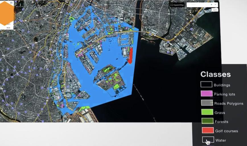
1. Esri (ArcGIS Platform)
Core capabilities:
- Enterprise GIS backbone
- Spatial data management and analysis
- Geostatistical modeling
- 3D urban modeling (ArcGIS Urban)
- Web GIS, dashboards, and reporting
Target industries: Government and municipal agencies, utilities and infrastructure operators, environmental regulators, defense and public safety.
Technology stack: ArcGIS Pro (desktop), ArcGIS Enterprise (server + portal), ArcGIS Online (cloud SaaS), integrations with Python, R, and REST APIs.
Pricing model: Traditional license-based (per user + enterprise tiers); cloud subscription options available.
Integration capabilities: Strong BIM interoperability (Autodesk), REST APIs and SDKs, enterprise connectors (ERP, asset management).
Positioning: Esri remains the default enterprise GIS, especially where regulation, procurement rules, and legacy processes matter. It's a big, well-supported ecosystem: dependable, deeply integrated, and widely adopted. Don't expect it to be the most experimental AI-first shop; think maturity and breadth rather than bells-and-whistles novelty.
2. Google Earth Engine (Google)

Core capabilities: Planet-scale satellite imagery analysis, time-series environmental monitoring, raster-based big-data analytics.
Target industries: Environmental monitoring, climate science, agricultural analytics, disaster risk modeling.
Technology stack: Cloud-native geospatial engine, JavaScript and Python APIs, large archive of satellite imagery.
Pricing model: Free for research and education; commercial pricing for enterprise use.
Integration capabilities: API-driven workflows, integration with Google Cloud Platform.
Positioning: Earth Engine is hard to top for large-scale remote-sensing work. Continental time series and long-term environmental trends are its sweet spot. It's ideal for scientists and analysts who need breadth and historical depth.
3. Mapbox
Core capabilities: Custom map visualization, location intelligence APIs, mobility and routing analytics.
Target industries: Mobility platforms and logistics, consumer-facing apps, automotive navigation.
Technology stack: Cloud-native mapping engine, SDKs for web and mobile, vector tiles and flexible styling.
Pricing model: Usage-based API pricing.
Integration capabilities: Strong developer ecosystem, mobile and embedded integrations.
Positioning: Developer-first and visualization-focused. If you want slick, interactive maps and mobility features, Mapbox is a top pick. But if your need is end-to-end urban modeling and planning workflows, it's not the whole toolbox.
4. Planet Labs
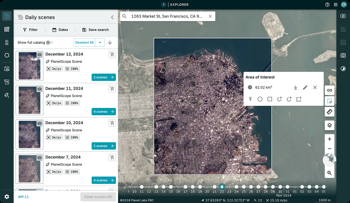
Core capabilities: High-cadence satellite imagery, near-daily global coverage, change detection workflows.
Target industries: Agriculture and land use, defense and security, environmental and infrastructure monitoring.
Technology stack: Proprietary satellite constellation, API delivery of imagery.
Pricing model: Subscription-based data access.
Integration capabilities: API integrations into GIS platforms, works well with Esri and other analytics tools.
Positioning: Planet is mainly a data shop: lots of frequent, high-resolution imagery. Think of it as the camera in the sky, with excellent raw footage, rather than the whole analytics darkroom.
5. Orbital Insight (Now Privateer)
Core capabilities: AI-driven satellite imagery analysis, economic activity and mobility indicators, infrastructure monitoring.
Target industries: Financial services and market intelligence, energy and utilities, supply-chain and defense.
Technology stack: Computer vision models, multi-source data fusion.
Pricing model: Enterprise contracts.
Integration capabilities: API integration, platform connectors for enterprise ingestion.
Positioning: Orbital Insight is strong on macro-level intelligence — satellite-derived indicators that reveal economic trends and mobility patterns. Useful for strategic, top-line insights; less aimed at the street-level detail planners often need.
6. Descartes Labs
Core capabilities: Geospatial AI platform, predictive modeling and analytics, environmental and commodity analytics.
Target industries: Climate risk analysis, agriculture and commodities, energy and government.
Technology stack: Cloud-native analytics pipelines, AI/ML modeling and sensor fusion.
Pricing model: Enterprise SaaS.
Integration capabilities: API-first architecture, cloud-native integrations.
Positioning: Descartes Labs focuses on geospatial AI for forecasting and environmental use cases. Pick them when you want predictive analytics driven by remote sensing — when trends and forecasts are the deliverables.
7. Digital Blue Foam (Urban Planning Specialization)
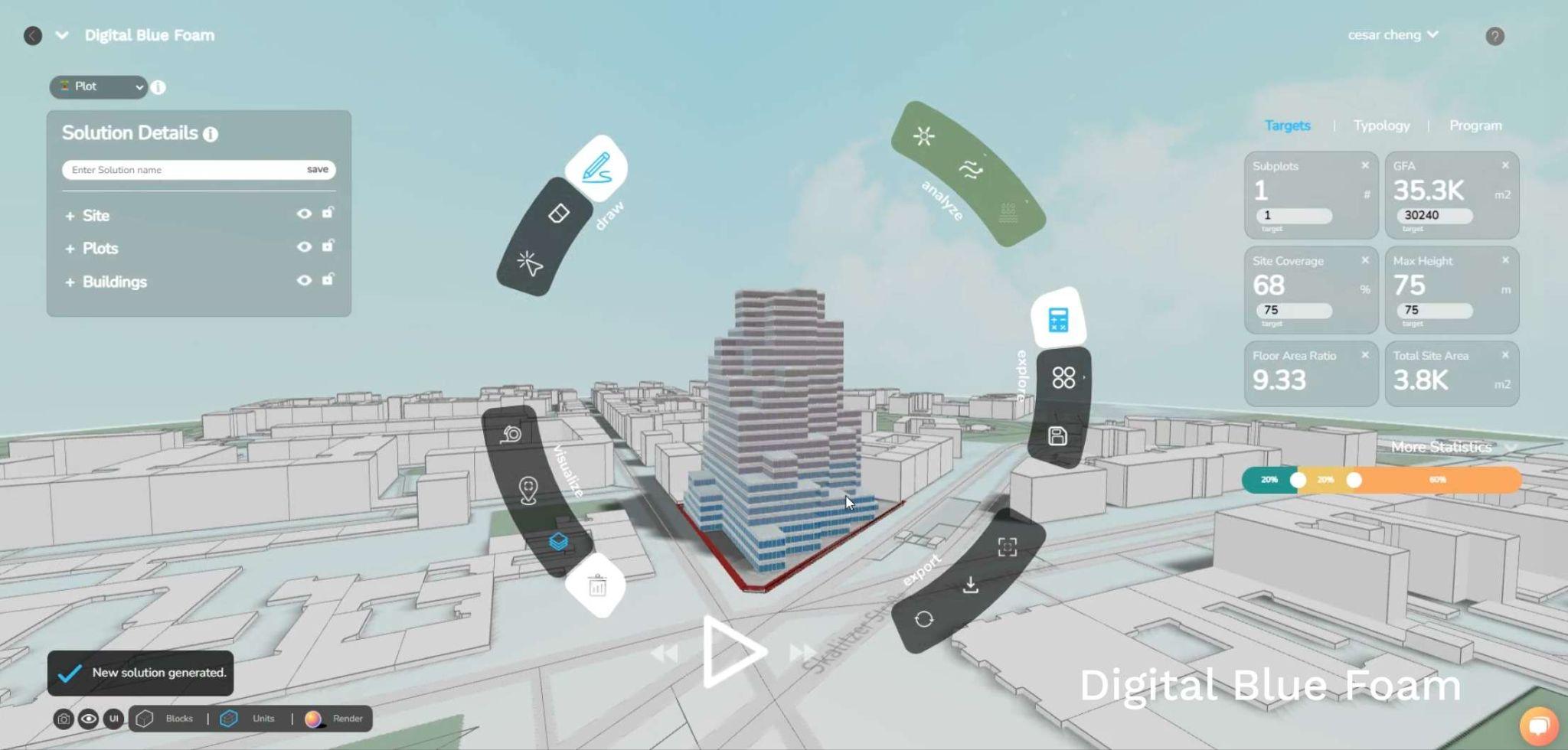
Core capabilities:
- AI-assisted masterplanning optimization
- Spatial analytics for zoning, density, and mobility
- Early-stage scenario testing
- Sustainability and carbon KPI integration
Target industries: Urban planners and municipal teams, real-estate developers, infrastructure authorities, masterplanned community developers.
Technology stack: Cloud-based spatial modeling, parametric scenario engines, GIS-integrated planning workflows, AI-driven land-use optimization.
Pricing model: Enterprise SaaS (project-based or subscription).
Integration capabilities: GIS data ingestion, BIM workflow compatibility, scenario exports for regulatory reporting.
Positioning: Digital Blue Foam targets decision intelligence at the urban scale rather than imagery-first workflows. Its strength is converting planning constraints, sustainability metrics, and density trade-offs into actionable scenarios — handy when you want to explore options instead of just collecting data.
Other notable players: Nearmap (high-resolution aerial imagery), CARTO (cloud-native spatial analytics), Palantir (heavy-duty integration and defense analytics), Bentley Systems (infrastructure digital twins). Each occupies a different layer of the geospatial AI stack and typically solves a particular slice of the problem.
Technology Stack Components
Enterprise geospatial AI solutions are built from a few core architectural layers. Below is a practical breakdown to help match vendor capabilities to project needs.
1. Data Acquisition Layers
This is the source layer and includes:
- Satellite imagery (multi- and hyperspectral)
- Drone surveys
- LiDAR scans
- IoT sensor feeds
- Mobility datasets
- Cadastral and parcel records
High-quality geospatial AI starts here. Get your ingestion pipelines right.
2. Processing Engines
Processing turns raw feeds into usable datasets. Key elements:
- Raster and vector processing frameworks
- Georeferencing and tiling systems
- Spatial indexing (H3, quadtrees)
- Cloud-native distributed compute
At enterprise scale, these engines must chew through petabytes of imagery and long time series without buckling.
3. Analytics Platforms
This is where AI/ML lives. Common functions:
- Object detection (buildings, roads, vegetation)
- Impervious surface and land-cover mapping
- Change detection across time
- Predictive urban-growth and demand modeling
- Risk modeling (flood, heat, congestion)
Modern platforms increasingly layer AI-assisted pattern recognition and forecasting on top of traditional spatial analysis.
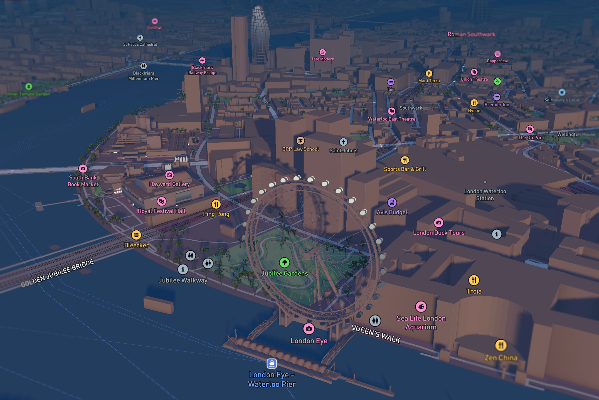
4. Visualization Tools
Analysis matters only if people can use it. Visualization ranges from:
- Web GIS dashboards
- 3D digital twins of urban districts
- Scenario comparison tools for planners
- Executive-facing reporting interfaces
Good visualization turns complex analysis into decisions, quickly and clearly.
5. API and Integration Capabilities
Adoption at scale depends on interoperability. Important integrations include:
- BIM systems (Autodesk, Bentley)
- ERP and asset-management platforms
- Sustainability reporting tools
- Cloud storage and data lakes
Today's geospatial AI platforms tend to be API-first and intentionally composable rather than stovepiped.
Stack Architecture Summary
A typical enterprise flow looks like:
Data acquisition → Processing → AI analytics → Visualization → Enterprise integration
Top vendors distinguish themselves not just by analytic sophistication but by how smoothly they bridge those layers — how easily imagery becomes insight, and insight becomes operational decision-making. In practice, the best choice is the one that fits your scale, your data sources, and the specific questions you actually need answered.
Selection Framework for Enterprise Teams
Choosing among geospatial analytics and AI vendors takes more than ticking boxes. Procurement needs a structured framework that aligns with long-term strategy.
1. Requirements Assessment
Start by being painfully specific:
- Geographic scale (district, metropolitan, regional, national)
- Primary use case (planning, monitoring, risk, operations)
- Required data types (imagery, LiDAR, sensor feeds)
- Integration touchpoints (BIM, ERP, ESG)
- Regulatory and reporting obligations
- Budget and in-house operational capacity
A crisp statement of objectives prevents buying bells and whistles you'll never use.
2. Evaluation Criteria
Score vendors on dimensions such as:
- Scalability and performance
- AI maturity and model explainability (can they justify predictions?)
- Data security and compliance posture
- Interoperability with your existing stack
- Vendor domain expertise (urban planning vs. environmental monitoring)
- Support, customization, and SLAs
For masterplanning, domain-specific workflow support often matters more than a generic analytics engine.
3. Decision Matrix Approach
Use a weighted scoring matrix to compare vendors objectively. Apply factor weights, run sensitivity checks, and align selections with strategic priorities.
| Criteria | Weight |
|---|---|
| Technical Capability | High |
| Integration Readiness | High |
| Domain Expertise | Medium |
| Cost Structure | Medium |
| Implementation Support | Medium |
| Long-Term Scalability | High |
Weighted scoring keeps solution choices tied to what the organisation actually cares about. It forces trade-offs into the open so decisions reflect priorities, not the loudest sales pitch.
4. Implementation Considerations
Picking a vendor is only the beginning. Teams must also map how a system will actually slot into day-to-day operations: ticketing flows, data lakes, on-call rotations and approval gates. Useful questions to ask are:
- Which deployment model matches your constraints and skills: cloud, hybrid, or fully on-prem?
- What data governance policies and controls must be in place before you onboard new sources?
- How will models be retrained, tested and maintained over months and years?
- What change management and user training programs will ensure adoption?
- What level of ongoing support and SLAs do you need from vendors?
In short, the decision-makers must match technology to operational maturity. Don't buy a high-end system you can't sustain.
Use Cases and Applications
Geospatial AI creates the most value when applied to measurable, concrete urban problems rather than treated as a generic capability.
1. Urban Planning and Development
Typical uses include land-use classification, density modelling, zoning compliance checks, folding carbon and sustainability KPIs into early designs, and comparing masterplan scenarios. Specialist planning tools weave spatial AI into design logic so teams can test options early, avoiding expensive rework once construction begins.
2. Infrastructure Projects
Common applications are corridor alignment analysis, monitoring construction progress, assessing asset condition, and mapping exposure to hazards. Satellite change detection, for instance, can replace many routine site visits, saving time and travel costs and speeding up decision cycles.
3. Smart City Initiatives
Geospatial AI can smooth traffic flows, monitor utility networks, feed live environmental sensors and enhance public-safety analytics. Paired with IoT and digital twins, these systems let cities react faster.
4. Environmental Monitoring
Use cases include urban heat-island mapping, flood-risk modelling, tracking air-quality trends and monitoring coastal erosion. Increasingly, these environmental models are baked into ESG strategies for urban development instead of being an afterthought.
Case Examples
- Satellite analytics firms supporting infrastructure monitoring
- GIS platforms underpinning municipal zoning systems
- AI tools that optimise density and spatial layouts in planning
- Digital twin integrations for large, masterplanned communities
Together, these examples show how broad and interconnected the geospatial AI ecosystem has become.
Future Trends
The geospatial AI market is moving quickly. Expect changes in technical capability, platform design and how vendors position themselves.
AI Advancement Impacts
Emerging capabilities include near-real-time geospatial inference, more accurate automated feature extraction, generative AI for simulating spatial scenarios and AI-assisted compliance checks. Crucially, model explainability will gain importance, especially for regulated urban projects where every decision may need an audit trail.
Emerging Technologies
Watch for high-revisit satellite constellations, edge computing for sensor analytics, spatial large language models that can reason about places, and wider use of synthetic data to train systems. Digital twin ecosystems are increasingly treating geospatial AI as core infrastructure rather than a bolt-on.
Market Consolidation Patterns
Expect data providers to acquire analytics firms, GIS incumbents to absorb AI startups, and urban platforms to broaden into sustainability and ESG toolsets. Enterprise buyers should plan for a shifting vendor landscape and favour integration-friendly, adaptable solutions.
As urban projects scale and complexity rises, companies that sit at the intersection of geospatial analytics and AI will shape how infrastructure is delivered, how sustainability targets are met and how cities build long-term resilience.
Conclusion: Selection Guidance and Strategic Positioning
For large urban and infrastructure programmes, geospatial AI is no longer optional. The real question is how to choose the right stack and partner from a crowded market.
Start with clarity of purpose. A satellite imagery provider is not the same as a planning intelligence platform. A visualisation API is not a predictive analytics engine. Infrastructure authorities, masterplanners and developers should define the dominant use case — monitoring, modelling, optimisation, compliance or scenario testing — before comparing tools.
A robust selection process should prioritise:
- Scalability across broad geographies
- Integration capability with BIM, GIS and asset-management systems
- Model transparency and explainability for regulatory confidence
- Domain specialisation aligned to urban planning or infrastructure delivery
- Long-term operability rather than pilot-stage novelty
For early-stage masterplanning, the differentiator is platforms that connect spatial data directly to planning logic. Satellite analytics excel at environmental monitoring and macro change detection, but urban projects need tools that understand zoning rules, density models, infrastructure geometry and sustainability KPIs within the decision workflow.
That's where urban-specialised platforms like Digital Blue Foam (DBF) try to position themselves differently. DBF aims to be more than an imagery analytics layer: it links spatial analytics, density optimisation, infrastructure planning and sustainability assessment into the early design and investment process.
Think in layered ecosystems:
- Data acquisition and environmental monitoring providers
- GIS and analytics platforms
- Urban planning optimisation tools
- Integration frameworks that connect spatial insights to financial and ESG reporting
The most resilient strategy is an interoperable architecture, not vendor lock-in. As projects grow and climate resilience becomes central, the geospatial AI framework you choose will influence operational efficiency, long-term asset value, regulatory compliance and competitive positioning. Choose for integration so spatial intelligence becomes a core capability, not a one-off experiment.
